 Photo Courtesy: nenow
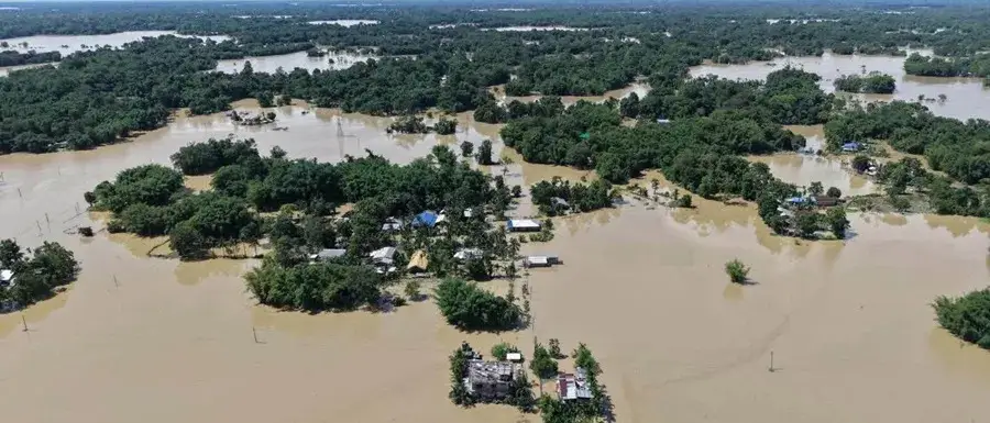
Guwahati: Devastating floods across 11 districts in Upper Assam have claimed more than 80 lives and displaced over 700,000 people. The disaster hit 800 villages, many of which had not seen flooding in 70 years. While officials initially blamed a cloudburst in the Naga Hills, the India Meteorological Department confirmed no such event occurred. Rumors of water releases from the Dikhu Hydroelectric Project also proved false, as the project remains stalled by land disputes and holds no operational reservoir.
The root of the crisis lies upstream in the Naga Hills. Decades of coal mining, hill cutting, and riverbed stone extraction have ravaged the environment. These activities have stripped away forest cover, forcing rainwater to runoff into the plains with unprecedented speed. Hydrologist Arup Kumar Sarma of IIT Guwahati warned that such environmental degradation destroys the natural capacity of the land to absorb water.
“Developmental activities like building roads or other infrastructures cutting down a lot of trees for mining or other work in hilly areas if done without a full study of how water moves and without taking care to grow more plants can change the flood situation a lot downstream especially when there is heavy rain in the hills that causes a lot of water and dirt to flow,” Sarma said.
Coal extraction, dominated by underground rat-hole mining and open-cast methods, has left the region unstable. The Dikhow river, which feeds the Brahmaputra, has been particularly hard hit by stone and boulder extraction. Former MLA Debabrata Saikia blamed illegal riverbed mining for tearing the river apart and worsening the inundation. Saikia previously filed a public interest litigation in 2019 to stop this trade, but court directives for a Mines and Mineral Task Force went largely ignored.
Compounding the problem is an infrastructure boom. Roads built to transport coal frequently dump debris directly into stream headwaters. This sediment settles in the Assam plains, filling riverbeds and forcing water to spill over embankments. The flood protection network had already suffered 18 embankment breaches and damage to 25 other structures between April 29 and July 6, before the main wave of flooding arrived.
Geographers and activists argue that the disaster reflects a shared ecological failure across the Northeast. With climate change fueling high-intensity rain, the saturated, deforested terrain cannot hold water. Experts suggest that future mitigation requires regional coordination, disaster preparedness committees, and strict reforestation efforts. Without a move away from unregulated exploitation of hill ecosystems, the region faces a future of even more severe and frequent catastrophes.





Comments